Today is my first day driving in Tasmania. In order not to find the parking space around the YH, I bring all my luggages and two packages of ingredients walking toward the office of Europcar. Unfortunately, it's raining now and the way to the office is the ascent. It's not a good start of the driving trip.
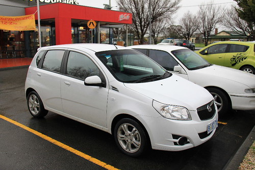
Because the driving direction in Australia is opposite to the direction in my country, the car is also a little different. First, the rain brush and headlight control is on your left, and the direction light control is on your right. Of course, the dirver's seat is on the right side, not the left. Except for these differences, there is nothing special to the car in my country.
I check the car very carefully to make sure that I won't make any mistake as driving on the road. In fact, I have to say that I don't like to drive in the area I'm not familar. Even I've walked around the Hobart city yesterday, I'm still a little nervious when I drive. Therefore, it's recommended that rentint a GPS with your car. It's not so easy to park anywhere for watching the road map, especially you travel alone.
My route today is heading for Richmod as my first stop, and then I will drive toward Port Arthur via Sorell. The total distance is about 120 km that is good for a new starter. However, the itinerary is changed as I saw the information on the plane yesterday. Besides, the price of the accommodations in Port Arthur is not cheap. Thus, I plan to stay at Tribunna or Swansea after visiting Port Arthur. If possible, I want to find the ferry information for Maria Island. For this change, the total distance becomes about 170 km.
I'm not sure whether I've listed Bonorong Wildlife Park as one of my destinations before. Google map tells me to drive the road C324 via B32 to Richmod. I drive quite carefully in such an umcomfortable raining day toward there. The cars are not too much on the road B32, and the road turns to be in the mounatain area as I enter the road C324. I think this way is not a shortcut for driving to Richmod, but I've got used to driving the mountain road as I travelled in Iceland, so it's still fine.
While I reach the road B31, I miss the right way and drive toward road A3. Oh, that's too bad. Though I know I have to make a U-turn, I'm a little afriad of other cars in the opposite direction. So, I go back to Hobart city after driving for an hour. It really depress me as I park in the parking area of the harbor. After resting for a while, I start again from Hobart city and drive the road B31 toward Richmod this time.

Do you think everything is fine after that? No, I make a mistake again. Because I don't find any attraction instructor when I arrive at Richmod, I make a circle around Richmod and go back to road B31 again.
So, where is the old bridge and the church? I don't find any map of Richmod in the guide book "Lonely Plant" and in the information paper I collected in Hobart. Although I wanted to find the map store yesterday, I didn't get one. I wonder why don't they erect any sightseeing instructor along the road that is close to the attraction? That is not friendly to tourists who drive by themselves for the frist time here. Maybe, these attractions are not so popular. Since I miss the birdge and church twice, it probably means that I should not try again.
The sky is still raining, and I leave here depressingly. Driving toward Sorell via road A3, the next destination is Port Arthur. In the hlaf way, I drive to somewhere unknown because I drive in the far left side of the road. Though I'm nervious, I'm lucky to find the correct way returning to the road A3. Anyway, in this first driving day, I have to try hard to get used to everything on the road.
About 10 o'clock, I take a rest at McDonald when I arrive at Sorell. There are parking spaces, and toilets. No wonder that it's the most ideal place for resting. I enjoy the warm breakfast and study my Lonely Planet once again. It's really not good that Lonely Planet only provides the maps of Hobartm Lauceston and Devonport. Besides, there is no free map for Richmod around Hobart.
So, is there any information about Richmod? Yes, I find the information about the attractions in Richmod after I search on the internet (Actually, I've finished the travel in Australia and come home at the moment I search the information). There is only a website (http://www.richmondvillage.com.au/thingstodo.html) that provides the information.
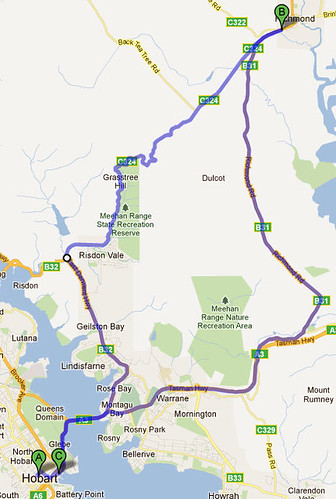
You may watch the map above. The old Richmond bridge built in 1828 is located at the point F which is quite close to the circle of B31 and C351. So, it means that I almost reach the bridge but I miss it for returning to road B31. As for St. John’s church, it is located at the point K that should be behind the bridge.
At this moment, I feel quite sad about missing these attractions in such a small town. Therefore, this event tells me that I should be more careful while making the plan, including making sure of all the maps and location information of all attractions. Sometimes, you just could not find these information when you are already there.
Leaving the McDonald, I continue driving toward Port Arthur on the road A9. Though renting a car is quite expensive expecially you are alone, the best thing is you could stop anywhere you like when you see beautiful scenery somewhere.
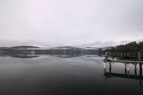
Sommer Bay is such a place that I make a short stop for its lake. I think this place should not be a famous attraction and the weather is also too cloudy. Howver, it's peaceful and the scene would be better if the weather is good.
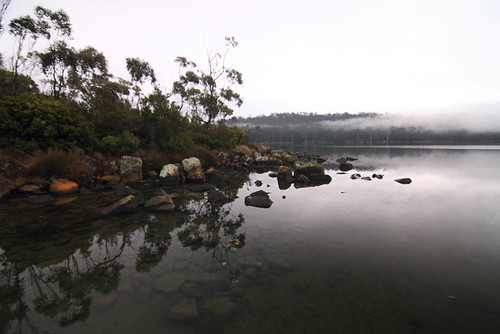
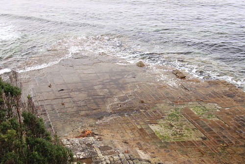
According to the information I have, there are some famous attractions located on the way to Port Arthur, such as Tesselated Pavement, Devil Kitchen, Tasman Arch and Eaglehawk Neck. However I waste my time on searching the attractions in Richmod, I only visit Tesselated Pavement before I arrive at Port Arthur.
Pavement which looks like Tofu or chessboard is a geographic formation on the sea shore formed under the rosion of the sand and wave. When you reach the parking area, you should follow the route for ten-minute's walk, or you will see only the beach, not the pavement. The flat rock with many lines caused by the nature power is quite like the floor of an old house, but the main building of this house has already disappeared.
As for the other three attactions, I make a short introduction about them.
Devil Kitchen is also a geographic feature, not a real kitchen. Devil kitchen is a rock shore located at the east of the peninsula, and formed by the erosion of the sea.
Tasman Arch is close to Devil Kitchen. It's an arch-like geographic formation.
Eaglehawk Neck is the isthmus at the narrowest section between Tasman sea and Norfolk bay. Basically, you have to go to the mountainside or the hill for watching or photographing of the neck. So I don't watch the neck, but I pass through it.
P.S There is a photo of Eaglehawk Neck provided by wikipedia: http://en.wikipedia.org/wiki/File:EaglehawkNeck.jpg

(This travel blog photo's source is TravelPod page: The Adventure Begins)
About one o'clock in the afternoon, I finally arrive at Port Arthur. It take about three hours to come from Sorell, but the time inlcudes visiting other attractions along the way. Port Arthur seems to be an old town according to the information I have, and the famous sightseeing spot is the heritage of the prison. But precisely speaking, Port Arthur is a private park because you have to buy the ticket before you enter into the heritage area from the tourist center. There are three kinds of passes. The basic one includes the ferry cruise and the guided tour. So, you have to make sure that you would like these old heritages when you list Port Arthur in your itinerary.

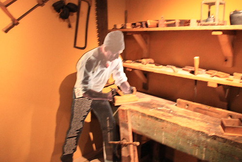
In the tourist center, they demostrate the working of the prison and what activities the prisoners did. These activities are related to the nature surrounging here, and the prisoners may be trained as the woodworkers, blacksmithes or stonemasons. Besides, you will get a card with your ticket. You could find the related box and know about the information of the prisoner in your card.
In the official website of Port Arthur, you could find a map of the whole park: http://www.portarthur.org.au/index.aspx?base=1315
Of course, they will give you a printed map with your ticket. You don't have to print the map in advance.
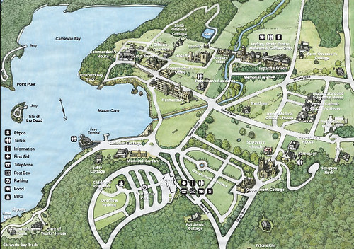
We could watch the map for a basic understanding of Port Arthur.
The leaf-shape area is the parking spaces, and you will find he tourists center around there.
The lake is located in the wast. There is a small island on the lake.
If you walk along the route by the lake to the north, the frist building is the heritage of the abandoned prison, and the guard tower and offices are around there.
Walking toward the north-eastern area, you could see the hospital, library and the famous separate prison.
Before you walk south to the tourists center via the garden, there are also the church and the officer's cottages.
Because the next ferry would be coming soon, I watch the Canadina Cottage on the half way.
This cottage is not an cottage anymore. There are only walls without anything left.
I'm quite curious why didn't them maintain this cottage and restore it to its original status.
Maybe they think the staus now is correspond to the name of a heritage.
I wait for the ferry at the quay. The ferry will take the tourists to look around the lake, and provide the transportation for the tourists joining the guided tour in the small islands on the lake. These guided tours are avaiable in other passes, but it's recommend to arrive here earlier for the schedule of these tours.
The scenery around the lake is nice, though it's raining a little. To a heritage park of the prisons, the scene here is a little similar to the green island in Taiwan. They were both the prisons once, but become the attractions for tourists nowadays. I don't know how did the prisoners think about their life here, but it should be nice to stay at such a place.
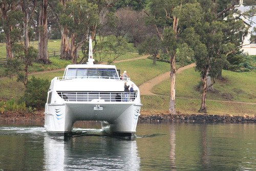

Taking a cruise on the lake, you could see the whole scene of the prison, guard tower and other heritages.
There is no huge wall around this prison area, but trees and mountains surround here. So, if someone wants to escape from the prison, it should be possible unless there are also beasts nearby.
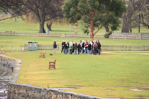
As we cruise on the lake, the broadcast will introduce the history of Port Arthur and you might know that the island on the lake, the Isle of the dead, is a graveyard in the past. And it's true that the prisoner tried to escape from here. By the way, the guided tour for the prison is also running and the number of the tourists is a lot in the low season.
Finishing the cruise, I continue visiting the heritages by myself according to the guide map.
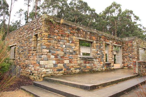
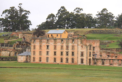
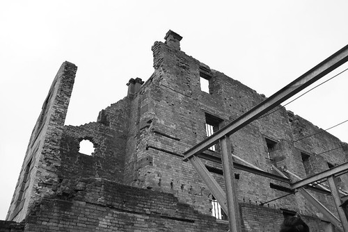
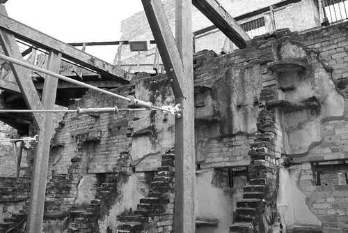
The broken building close to the lake is the Penitentiary which was built in 1843 as the place for flour manufacture and resotring and turned to be the prison in 1857 that could contain 480 prisoners. In 1897, a fire destroied this bulding and become what we see now.
The inner is allowed for visiting, but it's no more a complete building. In order to increase the strengh of these walls, there is the steel framework and the ropes. The guard tower is behind the Penitentiary, and the commandant's office and the hospital are also near. Except for the guard tower, each heritage seems to be the ruin now.
I wonder how could the tourists image the prison in the past just according to some walls or ruins? The buildings are no more complete, and they didn't restore these buildings. There is no furniture or something in that period. No one will care what these buildings are and the roles they played, because these buildings look the same.
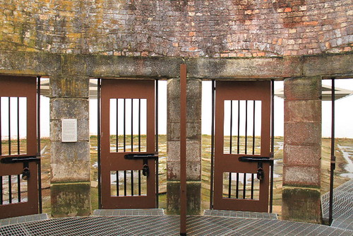
Walking to the north-eastern area, the museum displays the historic data of Port Arthur and you could have a rest in the nearby coffe shop. Then, the main point of visiting Port Arthur is the Separate Prison beside the coffee shop.
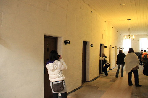
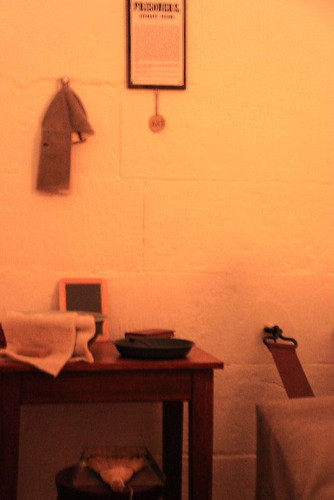
Saparate prison, as implied by its name, is the prison to enclose the prisoners saparately. Each prisoner live in a small room. In 1848, in order to cancel the group punishment, they decided to imprison these prisoners saparately to make them isolated from others and calm their spirits by the silence. That is the origin of building this prison. Except for the prisoners' rooms, there are also saparate outdoor areas for exercise. However, you could only watch the sky in this outdoor area with huge walls. So, it's quite boring to stay here.
Thus, saparated from others would be a very strcit treatment for someone. After all, you could not see anyone and there is nothing interest you could do.
Beside, in some serious situations, the prisoner might be enclosed in the dark room where you could not see anything even your fingers. That is quite terrible when you see nothing and only feel your soul. In some movies in Taiwan, there are also the actions that show you how the prisoners were punished by enclosed in this dark room. Except for your meals, you could not see any light and the room is so narrow that you could not do anything. After ten days or half a month, the prisoner was released with his weak body.
The Convict Church close to the garden is also a ruin nowadays which was built for the prisoners and the fire occurred in 1884.
I'm really curious why most of the heritages all become the ruins because of the fire? Maybe they didn't organize a fire brigade at that time.

About three o'clock, I finish the visiting in Port Arthur and the next is to find the accommodation in Tribunna or Swansea.
When I return to Sorell, I buy something at the supermarket. Finally, I find the analgesic cream and a knee guard for my left knee. That's a good news but the knee guard is a little expensive.
Driving along the road A3, the sky becomes dark after 5:30.
Oops, I forget the night in winter comes very early but it seems that I still have to dirve for more than an hour.
I have to say that driving in the dark in quite horrible for there is no road light in most of the area in Tasmania.
After the sunset, everything seems to be hidden in the dark except for the white lines and some yellow indicators.
If there is a car driving behind you with the big headlight, it's really uncomfortable. Sometimes I wish the car could overpass my car quickly and leave me alone.
At Six o'clock, I arrive at Tribunna. Though I only drive for an hour, it seems to be quite long in my mind.
Maybe it's the low season, I don't find any store opening at the night. Of course, I could not find the hostel and restaurant as well.
It's bad that I don't have any information and map for this town. Therefore, I have to try hard again to drive to Swansea.
If I could not get the information about the ferry schedule of Maria Island, or there is no ferry to Maria Island tomorrow, staying at Swansea tonight could let me enjoy the day in Freycinet two hours earlier.
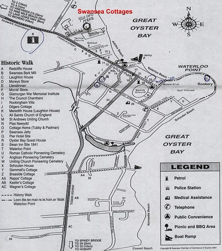
The accommodation in my pocket is the Swansea Backpacker which was collected in Hobart. The address of this hostel looks quite simple that should be on the side of the road A3. However, no matter how I try to search it on the road A3 inside Swansea, I just could not this hostel.
Though I think of getting a room in the Motor Inn, the recpetion is also closed.
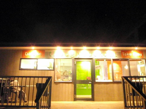
Fortunately, there is a restaurant still avaible just close to the Motor Inn. Anyway, I have to eat something and try to find more information to get a accommodation tonight.
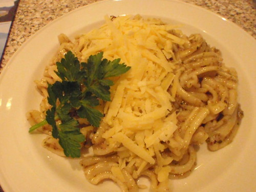
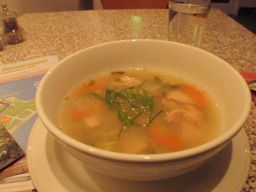
I order a pesto and a chicken soup. The price is fine and there is only me in this restaurant.
The soup is delicate with chicken, carrot and etc., and the pesto should be a kind of italian pasta in which the source is thick and there is the cheese on the top.
After enjoying the meal, I ask the staff for the location of Swansea Backpacker, and it should be located along the road A3.
Besides, I find the ferry schedule in the restaurant, but it's a pity that there is not ferry tomorow. The ferry is only available on Monday, Wednesday, Firday ans Sunday in the low season.
So it means that I could spend the day tomorrow in Freycinet national park.
Here is the schdule for Maria Island Ferry:http://www.mariaislandferry.com.au/
| Tribunna | Darlington (Maria Island) | ||
| October to mid December | Mon, Wed, Fri, Sun | 9:30 a.m | 10:30 a.m |
| 4:00 p.m | 5:00 p.m | ||
| mid December to mid April | Daily | 9:30 a.m | 10:30 a.m |
| 4:00 p.m | 5:00 p.m | ||
| mid Aprial to end September | Mon, Wen, Fri, Sun | 10:30 a.m | 11:30 a.m |
| 3:00 p.m | 4:00 p.m |
Fare:Adult $50, Child (6-16) $37, Child (2-5) $25, Bikes / Kayaks $10 - $20
I try to find the backpacker one more time with a slight hope.
It's really strange that I just could not find any building that looks like the backpacker I want to stay.
There are only two hotel accommodations along this road, and the map is too simple that it's hard to guess where the hostel is.
Since I have tries so many times, I decide to find any accomodation which is still lighting regardless of the price.
So, Swansea Cottages is the final one I choose to stay tonight. There is one cottage available and the price is 120 AUD.
When I check in at the recpetion, the staff telle me that there is an entrace to the beach nearby and draws the route on my map.
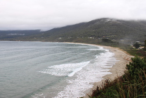
It's a good news that I could watch the sunrise and the sea tomorrow morning.
My cottage is comfortable with a small fridge, an electric kettle, a television and etc.
The most important of all, there are a big confortable bed and a warn washroom.

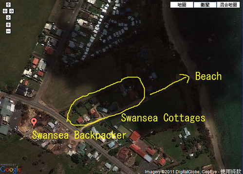
As for the Swansea Backpacker, where is it? I try to search it on the internet.
In fact, it should be very close to Swansea cottages, but is not located beside the road A3.
You might watch the map below. The backpacker is located on the red point I put on the map.
There is no indicator for this backpacker on the road A3 and I think it's quite hard to find it in the dark night if you didn't search the location information in advance.
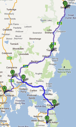
Today's Route ---
A:Hobart
B:Richmod (Missed)
C:Sorell
D:Eaglehawk Neck (Only Pass)
E:Port Arthur
F:Tribunna (Only Pass)
G:Swansea

 留言列表
留言列表
